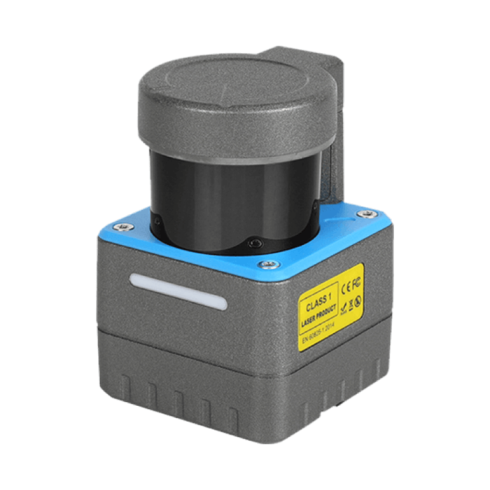
OLEI Laser / Camera (LR-1BS5H)
In stock
- BRAND:
- OLEI
- MODEL:
- LR-1BS5H
- PART #:
- LR-1BS5H
- ORIGIN:
- China
- Warranty:
- 12 MONTHS
- AVAILABILITY:
- SUBJECT TO AVAILABILITY
- SKU:
- SEER-Robotics-OLEI-LR-1BS5H
OLEI Laser / Camera (LR-1BS5H)
A mobile robot knows its surroundings only as well as its sensor reports them, sweep after sweep. A sensor built to see widely may see coarsely, and one built to see finely may leave blind sectors around the machine. The OLEI Laser / Camera (LR-1BS5H) addresses that tension directly. It is a laser scanner that covers a 270-degree arc at a fixed angular resolution of 0.225°. It delivers a maximum point cloud density of 40k/s, carrying azimuth, distance and reflection intensity data for SLAM navigation and point cloud obstacle avoidance.
Robots Europa, based in Dublin, supplies the LR-1BS5H to robot builders, system integrators and fleet operators throughout the European Union and the DACH region. Robots Europa prepares each quotation for the configuration you specify, including the protection class. It then arranges delivery to your site and provides technical support once the scanner is in service.
Background
OLEI and the LR-1BS5 series
The LR-1BS5H belongs to OLEI's LR-1BS5 series of laser scanners. The sources name further versions within this family and its neighbourhood, among them the LR-1BS5+ and the LR-1BS2. The manufacturer describes the LR-1BS5 series as suited to several industries: robotics, security and surveillance, industrial automation and smart logistics. That breadth reflects how this class of sensor is used in practice. The same scanning principle that lets an autonomous mobile robot locate itself in a warehouse can also watch a perimeter, guard a machine cell or measure the space around a conveyor. Each version in a family of this kind carries its own specification. The figures on this page therefore refer to the LR-1BS5H alone and should not be read across to its siblings.
Configurable signal handling
The LR-1BS5H stands out less for any single headline figure than for how much of its signal processing the user can adjust. It offers a user-settable weak signal threshold, so the sensitivity of detection can be matched to the scenario in which the scanner works. It also includes a built-in multi-level filtering algorithm, which the customer can configure to deal with tailing. Tailing is the familiar laser-scanning artefact in which spurious points appear to trail behind the edges of objects. Left unfiltered, those phantom points can confuse mapping software or trigger needless avoidance manoeuvres. Being able to tune both the threshold and the filtering lets an integrator commission the sensor for the real site rather than for an idealised test bench.
Technical Specifications
| Specification | Value |
|---|---|
| Scanning angle | 270 degrees |
| Angular resolution | 0.225° (fixed) |
| Horizontal plane error | ±1° |
| Maximum point cloud density | 40k/s |
| Data provided | Azimuth, distance, reflection intensity and other data |
| Weak signal threshold | User-settable strength adjustment |
| Filtering | Built-in multi-level filtering algorithm, customer-settable, against tailing |
| Protection class | IP65 or optional |
| Certifications | FCC, EMC, CE, RoHS, REACH, FDA |
| Intended use | SLAM navigation and point cloud obstacle avoidance |
Specifications are as published by the manufacturer and are confirmed against the datasheet at quotation. The manufacturer has not published the power consumption, the operating humidity, the output interface types or the contents of the box; these are confirmed with your quotation.
Why does angular resolution matter for SLAM navigation?
SLAM software builds a map and locates the robot within it simultaneously. It does this by matching each new scan against the features it has already seen. The finer the angular spacing between measurement points, the more detail each scan contains: corners stay sharp, thin pillars are not missed and narrow gaps register as gaps. The LR-1BS5H uses a fixed 0.225° angle resolution. Because the spacing does not vary, the localisation software receives a consistent point pattern from one revolution to the next.
The wide field matters just as much. A 270-degree scanning angle covers the front and both flanks of a vehicle from a single mounting point, leaving only the sector behind the sensor unobserved. On many robot chassis that rear sector is taken up by the vehicle body anyway. One sensor can therefore supply both the navigation map and the obstacle picture, which simplifies wiring and calibration.
Point density and geometry complete the picture. A maximum point cloud density of 40k/s gives the planner a dense, frequently refreshed view of the environment. A horizontal plane error of ±1° keeps the scanning plane level enough to preserve the horizontal scanning distance that navigation depends on. Each point also carries reflection intensity alongside azimuth and distance. Navigation software can use intensity to distinguish reflective markers from ordinary surfaces, which helps in long, repetitive aisles where geometry alone is ambiguous.
How does the LR-1BS5H handle difficult surfaces and edges?
Real sites are rarely kind to laser scanners. Dark materials return weak signals, glossy packaging scatters light, and the edges of racking and machinery produce the tailing artefacts described above. The LR-1BS5H tackles these conditions on two fronts. The adjustable weak signal threshold lets you decide how faint a return must be before it counts as a measurement, balancing sensitivity against noise for the site in question. The multi-level filtering algorithm, set by the customer as needed, then removes the trailing points that would otherwise blur the outline of an object.
For the integrator, this means less work downstream. Cleaner point clouds reach the navigation stack, so less filtering has to be written in the robot's own software, and obstacle avoidance reacts to objects that are actually present. The manufacturer quotes a protection class of IP65 or optional, so the enclosure can be discussed for the environment in question. The certifications listed for the LR-1BS5H are FCC, EMC, CE, RoHS, REACH and FDA, and CE marking is the reference point for machines placed on the market in the European Union.
Who is the OLEI Laser / Camera (LR-1BS5H) for?
The first group is builders of autonomous mobile robots and automated guided vehicles. They need one sensor that serves both SLAM navigation and obstacle avoidance, and the wide arc, fixed angular resolution and configurable filtering speak directly to that need. Teams developing vehicles for warehouses and distribution centres will find related platforms in our Logistics Robots category.
The second group is system integrators in industrial automation. For them the scanner serves as an environmental sensor on production lines, around machine cells or on factory transport robots; our Factory Robots category shows the kinds of machines into which such a sensor is integrated. The third group is security and surveillance specialists, for whom a laser scanner's ability to detect presence and movement across a wide arc complements camera systems.
Research groups and engineering departments prototyping their own robots also benefit from the configurable signal handling. It lets them study how threshold and filter settings affect their mapping results. Buyers comparing versions within the OLEI family can also review the OLEI Laser / Camera (LR-1BS2). Robots Europa will set out the published differences between the two in the quotation, so that the choice rests on confirmed figures.
What is the OLEI Laser / Camera (LR-1BS5H) used for?
- SLAM mapping and localisation: building and maintaining the map that an autonomous mobile robot uses to know where it is.
- Point cloud obstacle avoidance: detecting people, pallets and fixtures in the vehicle's path so that it can slow, stop or re-route.
- Smart logistics: guiding transport robots through warehouse aisles, loading zones and picking areas.
- Industrial automation: monitoring the space around machines, conveyors and work cells on the factory floor.
- Security and surveillance: watching a wide arc for presence and movement in areas that cameras cover poorly.
- Robot development: giving prototypes and research platforms a configurable laser sensor for navigation experiments.
Pricing and Availability
Robots Europa supplies the LR-1BS5H on a quotation basis, so that the configuration, protection class and documentation match your project before you commit. Delivery, customs and technical support are arranged together with your quotation. Tell us about your robot platform, operating environment and intended quantities, and we will confirm the details against the manufacturer's datasheet. The request form for a quotation for the OLEI Laser / Camera (LR-1BS5H) is available on this page.
Frequently Asked Questions
What scanning angle does the LR-1BS5H cover?
The LR-1BS5H covers a scanning angle of 270 degrees. This lets a single sensor observe the front and both sides of a vehicle.
What angular resolution does it offer?
It has a fixed angle resolution of 0.225°. Because the resolution is fixed, the navigation software receives a consistent point pattern on every scan.
What data does the scanner provide?
It provides azimuth, distance, reflection intensity and other data. The maximum point cloud density is 40k/s.
Can the sensor be tuned for difficult environments?
Yes. The weak signal threshold is user-settable, and the built-in multi-level filtering algorithm can be configured by the customer to deal with tailing at object edges.
Which certifications does the LR-1BS5H hold?
The listed certifications are FCC, EMC, CE, RoHS, REACH and FDA. The protection class is IP65 or optional.
Are the power consumption and interfaces published?
The manufacturer has not published the power consumption, operating humidity, output interface types or box contents. Robots Europa confirms these with your quotation.
Where can I buy the OLEI Laser / Camera (LR-1BS5H) and what does it cost?
You can buy it from Robots Europa, which supplies customers across the EU and the DACH region from Dublin. The cost depends on configuration and quantity and is set out in a quotation that you can request on this page.
Summary
The tension between seeing widely and seeing finely runs through every choice of navigation sensor. The LR-1BS5H answers it by pairing a 270-degree arc with a fixed 0.225° angular resolution and a maximum point cloud density of 40k/s. Its adjustable weak signal threshold and customer-settable multi-level filtering let that detail survive on real sites, with dark surfaces, glossy packaging and sharp edges. For builders of mobile robots, integrators in factories and logistics, and security specialists, it offers one configurable sensor for SLAM navigation and obstacle avoidance. Robots Europa confirms the open specifications and arranges delivery and support. If you are planning a robot that needs to see both wide and sharp, this page is the starting point.