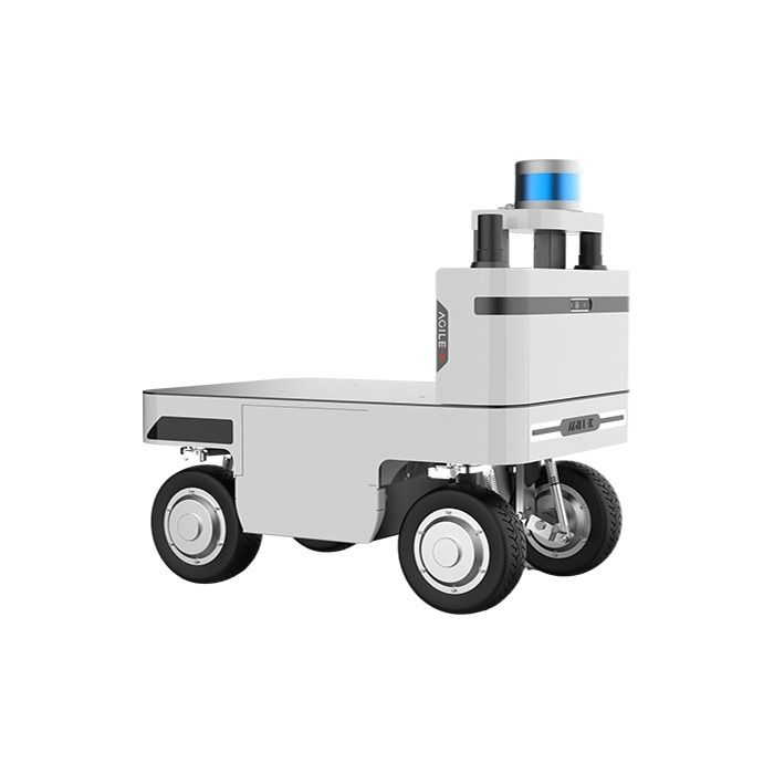
Agilex NAVIS Autonomous Navigation System
In stock
- BRAND:
- AGILEX
- PART #:
- NAVIS
- ORIGIN:
- China
- AVAILABILITY:
- SUBJECT TO AVAILABILITY
- SKU:
- AgileX-NAVIS
Agilex NAVIS Autonomous Navigation System
Most mobile robots can drive long before they can find their way. A chassis with capable motors and a sturdy frame will cross a warehouse floor on command, yet it has no idea where the racking ends, where a pallet was left this morning or which aisle a forklift has just blocked. The Agilex NAVIS Autonomous Navigation System exists to close that gap. It gives industrial robots and AGVs the perception, planning and decision-making they need to move on their own through semi-enclosed and enclosed environments, and it lets the people responsible for those robots step in whenever a situation calls for a human hand.
Robots Europa, based in Dublin, supplies NAVIS to system integrators, machine builders and research organisations across the European Union and the DACH region. We prepare quotations for single units and for fleet projects, arrange delivery to your site and remain your point of contact for technical questions once the system is in service.
Background
AgileX and the step from chassis to autonomy
AgileX Robotics is best known for its mobile robot platforms and development kits, used by research groups, integrators and industrial teams that need a dependable base on which to build their own applications. NAVIS extends that range in a different direction: rather than another vehicle, it is the navigation layer that turns a platform into an autonomous machine. Its modular structure of NAVIS Brain, NAVIS Bridge and NAVIS Board allows the system to be integrated flexibly into various UGV platforms, so it is not bound to a single body or a single application. The wider range of platforms and kits from the manufacturer can be found in our AgileX category.
LiDAR-IMU fusion at the core
The central technology of NAVIS is proprietary LiDAR-IMU sensor fusion. The system combines solid-state LiDAR, depth cameras and an IMU into one sensor fusion platform, and it integrates and processes data from various onboard sensors and systems to build its picture of the surroundings. In general terms, fusion of this kind is what allows a robot to hold a stable position estimate where a single sensor would struggle: LiDAR supplies the geometry of the space, the IMU tracks motion between scans, and depth cameras add detail close to the vehicle. On that foundation NAVIS runs real-time path planning and adjustment, obstacle detection and avoidance, and intelligent decision-making algorithms, which together produce what AgileX calls dynamic navigation.
Technical Specifications
| Specification | Value |
|---|---|
| Product type | Autonomous navigation system for semi-enclosed and enclosed environments |
| Navigation method | Proprietary LiDAR-IMU sensor fusion, real-time path planning and adjustment, obstacle detection and avoidance, intelligent decision-making algorithms |
| Sensors | Solid-state LiDAR, depth/stereo cameras, IMU |
| Mapping area | 2 mil. ㎡ |
| Mapping | One-Click Mapping |
| Map editing | Real-time map editing tools for on-the-fly adjustments |
| Positioning accuracy | approx. ±3-5 cm |
| Repeat position accuracy | ±8cm |
| Travel positioning accuracy | ±10cm |
| Maximum navigation speed | up to approx. 2.5 m/s |
| Core system components | Navigation Panel, Task Management System, Visual Feedback System |
| Modules | NAVIS Brain, NAVIS Bridge, NAVIS Board |
| Safety features | Collision avoidance, virtual barriers, emergency stop |
| Software features | Mapping, path planning, task management, fleet coordination |
| Remote takeover | Remote control allowing immediate human intervention or guidance |
| Integration | SDK, API and ROS2 compatibility for industrial robots and AGVs |
| Dashboard | Custom data dashboard for desktop or mobile device |
| Scope of delivery | NAVIS Brain (main processing unit); wiring harness and mounting accessories |
Specifications are as published by the manufacturer and are confirmed against the datasheet at quotation.
The manufacturer has not published the dimensions, weight, power supply, power consumption, LiDAR model and range, camera resolution, operating temperature, IP rating, communication interfaces or a list of supported chassis; Robots Europa confirms these details with you at quotation.
What does NAVIS add to a robot that can only drive?
A bare platform executes commands; NAVIS decides which commands make sense. The system is built from three core components that work together. The Navigation Panel is where routes and maps are handled, the Task Management System organises what the robot is supposed to do and in which order, and the Visual Feedback System shows operators what the robot perceives and how it is progressing. Software functions for mapping, path planning, task management and fleet coordination sit on top of this structure, so the same installation can serve one robot or several working side by side.
Mapping starts with One-Click Mapping, and the system covers a mapping area of 2 mil. ㎡. That scale matters for sites where a robot must work across an entire hall, a campus of buildings or a long covered yard rather than a single room. Because real sites change, NAVIS provides real-time map editing tools: when a new storage zone appears, a passage is closed or operational requirements shift, the map can be adjusted on the fly instead of being recorded again from the beginning.
Safety is handled on several levels. Collision avoidance and obstacle detection react to what the sensors see, virtual barriers keep the robot out of areas it must not enter, and an emergency stop halts it outright. Above all of this sits remote takeover, which allows immediate human intervention or guidance whenever a situation goes beyond what the robot should resolve alone. A custom data dashboard, usable on any desktop or mobile device, turns the operating data into visualisations for real-time insight and on-the-fly analysis.
How is NAVIS integrated into existing robots and AGVs?
NAVIS is designed to be added to industrial robots and AGVs rather than to replace them. AgileX supplies an SDK, an API and ROS2 compatibility, together with detailed implementation guides and technical support, so that development teams can connect the navigation system to their own control software and application logic. For teams already working in ROS2, this means NAVIS fits into a familiar toolchain rather than demanding a separate one.
On the hardware side, the scope of delivery comprises the NAVIS Brain as the main processing unit, together with a wiring harness and mounting accessories. The modular split between NAVIS Brain, NAVIS Bridge and NAVIS Board is what allows the system to be fitted to various UGV platforms. We recommend sending us the details of your intended platform with your enquiry, so that the fit can be checked before you commit to the project.
Who is the Agilex NAVIS Autonomous Navigation System for?
The first group is system integrators who deliver autonomous solutions to end customers. For them, NAVIS offers a navigation layer that can be reused across projects and platforms, with an SDK and API to build the customer-specific parts on top. The second group is manufacturers of AGVs and industrial vehicles who want to add autonomy to their own products without developing localisation and path planning from scratch.
Operators of logistics, production and facility sites form the third group: organisations that already run, or plan to run, mobile robots in large halls and semi-enclosed areas and need maps that can be maintained as the site changes. Finally, universities and research institutes working on autonomous mobility will appreciate the ROS2 compatibility and the combination of LiDAR, depth cameras and IMU as a basis for experiments and prototypes. Teams who still need a suitable platform alongside the navigation system can browse the AgileX range and ask Robots Europa for advice on a combination that suits the project.
What is the Agilex NAVIS Autonomous Navigation System used for?
- Warehouse logistics: autonomous transport of goods between storage zones, picking areas and dispatch.
- Production intralogistics: supplying assembly lines with material and removing finished parts without fixed tracks.
- Semi-enclosed sites: navigation through covered yards, loading areas and transitions between halls.
- Inspection and patrol: regular rounds through large facilities with tasks scheduled in the Task Management System.
- Fleet operation: coordinating several robots that share the same map and working area.
- Research and development: building and testing autonomous mobility applications on ROS2.
Pricing and Availability
Robots Europa supplies the Agilex NAVIS Autonomous Navigation System on the basis of an individual quotation, as the configuration depends on your platform, the number of robots and the integration support you require. Delivery, customs and support are arranged together with the quotation, so you receive one complete offer for your project. Please tell us about your vehicle, your site and your intended tasks, and we will prepare a tailored proposal; the quotation request is available on this page.
Frequently Asked Questions
Which environments is NAVIS designed for?
NAVIS enables robots to navigate autonomously in both semi-enclosed and enclosed environments, such as halls, warehouses and covered outdoor areas.
Which sensors does NAVIS use?
The system combines solid-state LiDAR, depth cameras and an IMU into one sensor fusion platform built on proprietary LiDAR-IMU fusion.
How large an area can NAVIS map?
NAVIS covers a mapping area of 2 mil. ㎡, created with One-Click Mapping. Maps can then be adjusted in real time with the map editing tools.
Can an operator take over control of the robot?
Yes. Remote takeover allows immediate human intervention or guidance, complementing collision avoidance, virtual barriers and the emergency stop.
Does NAVIS work with ROS2?
Yes. NAVIS offers ROS2 compatibility alongside an SDK and an API, supported by implementation guides and technical support for integration into industrial robots and AGVs.
What is included in the delivery?
The scope of delivery comprises the NAVIS Brain as the main processing unit, together with a wiring harness and mounting accessories.
Where can I buy the Agilex NAVIS Autonomous Navigation System and what does it cost?
You can obtain NAVIS from Robots Europa, which supplies customers throughout the EU and the DACH region. The cost depends on your configuration and is set out in an individual quotation, which you can request on this page.
Summary
The distance between a robot that drives and a robot that navigates is filled with perception, planning and judgement, and that is precisely the ground NAVIS covers. Proprietary LiDAR-IMU sensor fusion, a mapping area of 2 mil. ㎡, maps that can be edited as the site changes, layered safety functions and remote takeover give an industrial robot or AGV the ability to work independently while keeping people in control. With an SDK, an API, ROS2 compatibility and a modular hardware structure, the system is built to be added to existing platforms rather than to replace them. If your robots are ready to move but not yet ready to find their own way, this page is the starting point.